Now Reading: Caminito del Rey Travel Guide: Everything You Need to Know Before You Go
-
01
Caminito del Rey Travel Guide: Everything You Need to Know Before You Go
Caminito del Rey, also known as the King’s Little Pathway, is a legendary 8 km road in the centre of the Málaga province in Spain. Known as a dangerous walkway in the past, with several fatal accidents, this historic walkway has been restored to provide visitors with an exhilarating and safe hiking experience.
The trail, first constructed in the early 1900s, was initially created to serve the workers of hydroelectric plants, and it was named after King Alfonso XIII, who walked it in 1921. The route passes through the spectacular Gaitanes Gorge and also has some of the most spectacular scenery in Andalusia.
The modern Caminito del Rey has boardwalks, steel barriers, and mesh covering to ensure that visitors can walk safely through the spectacular mountain landscape.
It is generally thought to be a moderate hike that takes between 3 and 4 hours, and it runs between Ardales and El Chorro, dropping approximately 300 meters in elevation. It has several popular locations, such as Butter Stairs, Puente del Rey, and the Hanging Bridge, and is a favorite among photographers.
The trail must be booked in advance as it is very popular, and the regular ticket costs 10, and guided tours cost 18. Shuttle buses can also be used to carry visitors between the start and end points for those who are not keen on walking.
Caminito del Rey is a part of a bigger biosphere reserve, which adds more value to this nature lover’s site as a safeguarded zone in the Desfiladero de los Gaitanes Natural Park.
Caminito del Rey is an exhilarating and picturesque adventure destination, whether you are an adventure-seeker, a history lover, or want to enjoy the splendid natural scenery.
In order to have a safe visit, visitors should wear helmets, closed shoes, and adhere to all the safety rules. It is best to come in spring or fall, when the weather is not hot and humid, and make advance plans for tickets and transportation.
Location & Map Context of Caminito del Rey
Caminito del Rey lies in the Desfiladero de los Gaitanes Natural Park in central Málaga province, Andalusia, about 60 km north of Málaga city. It spans Ardales and Álora municipalities.
The start (north entrance) is at Puerto de las Atalayas (Ardales), 57.7 km from Málaga; the hike ends at El Chorro train station near Álora. A Google Maps search shows it between the Conde del
Guadalhorce and Guadalhorce rivers in dramatic mountain terrain. The area is a protected natural park and part of an Andalusia-Morocco biosphere reserve.
- Visitors’ Reception Centre (Puerto de las Atalayas): Main entrance 57.7 km from Málaga. Parking here (2 €/day) feeds a shuttle bus to the trailhead.
- Northern Access (El Kiosko area): Two hiking paths begin near the El Kiosko restaurant by Ardales reservoirs, entering via tunnels.
- Southern Exit (El Chorro/Álora): Exit at El Chorro (Álora) station; return shuttle or train from here.
Map: The trail forms a linear corridor from Ardales (north) down through the gorge to El Chorro (south). No vehicles reach the start; approach by shuttle or hike. The official website maps the route and access points.
History and Restoration Timeline
A quick timeline of key events – see the mermaid chart below – will help contextualize this historic trail.
Caminito del Rey – Key Events
1901: Construction begins on the stone pathway
1905: Construction completed (3 km long)
1921: King Alfonso XIII walks the trail, dubbed “Caminito del Rey.”
1999: Fatal accidents on original path; deteriorating structure
2000: Trail officially closed by authorities
2014: Restoration project begins
2015: Reopened to the public (March 2015)
2019: UNESCO World Heritage candidacy filed (Nov 2019)
2025: Recent climbing fatalities reported in the area
The Caminito was originally built from 1901 to 1905 to aid in the construction of local hydroelectric plants. It was a narrow, one-meter-wide cement path attached to rock walls.
In 1921, King Alfonso XIII inaugurated it, gaining its name “King’s Little Pathway”. Over the decades, it fell into disrepair; by 1999, several hikers fell to their deaths, prompting permanent closure in 2000.
After 14 years closed, a major restoration (Feb 2014–Mar 2015) rebuilt the walkways with steel and wood, widened the path, and installed railings and cable mesh.
The new path follows the original route and reopened on 28 March 2015. In 2019, local authorities officially began seeking UNESCO World Heritage status for the Caminito and its surroundings, highlighting its industrial and natural value.
Recent news has also highlighted safety. In late 2024–2025, two rock climbers near Caminito del Rey died in falls. (Both incidents were on adjacent climbing routes, not the fenced official path.) Nevertheless, these tragedies remind visitors to heed safety rules even on restored sections.
Trail Route and Description for Caminito del Rey
Caminito del Rey’s boardwalk winds hundreds of meters above the gorge. The one-way hike starts in Ardales (north) and descends to El Chorro (south).
The entire route is about 8 km one-way, with an elevation drop of roughly 300 m. Average visit time is 3–4 hours.
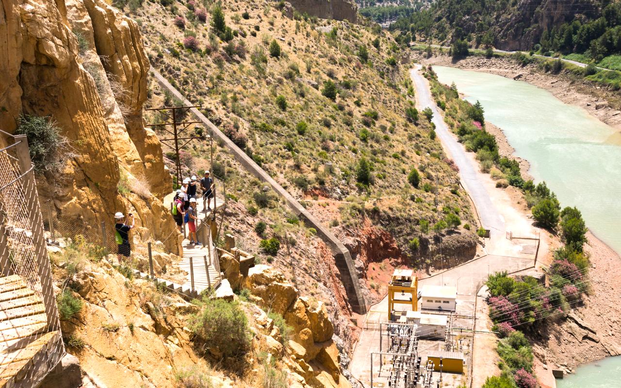
North Entrance (Ardales): There are two pedestrian accesses via tunnels by the El Kiosko restaurant. Both lead down to the “Control Booth” (ticket check and helmets) at the old hydroelectric substation (start of official trail). The longer access (2.7 km) starts at the “Túnel Grande”; the shorter (1.5 km) via a smaller tunnel.
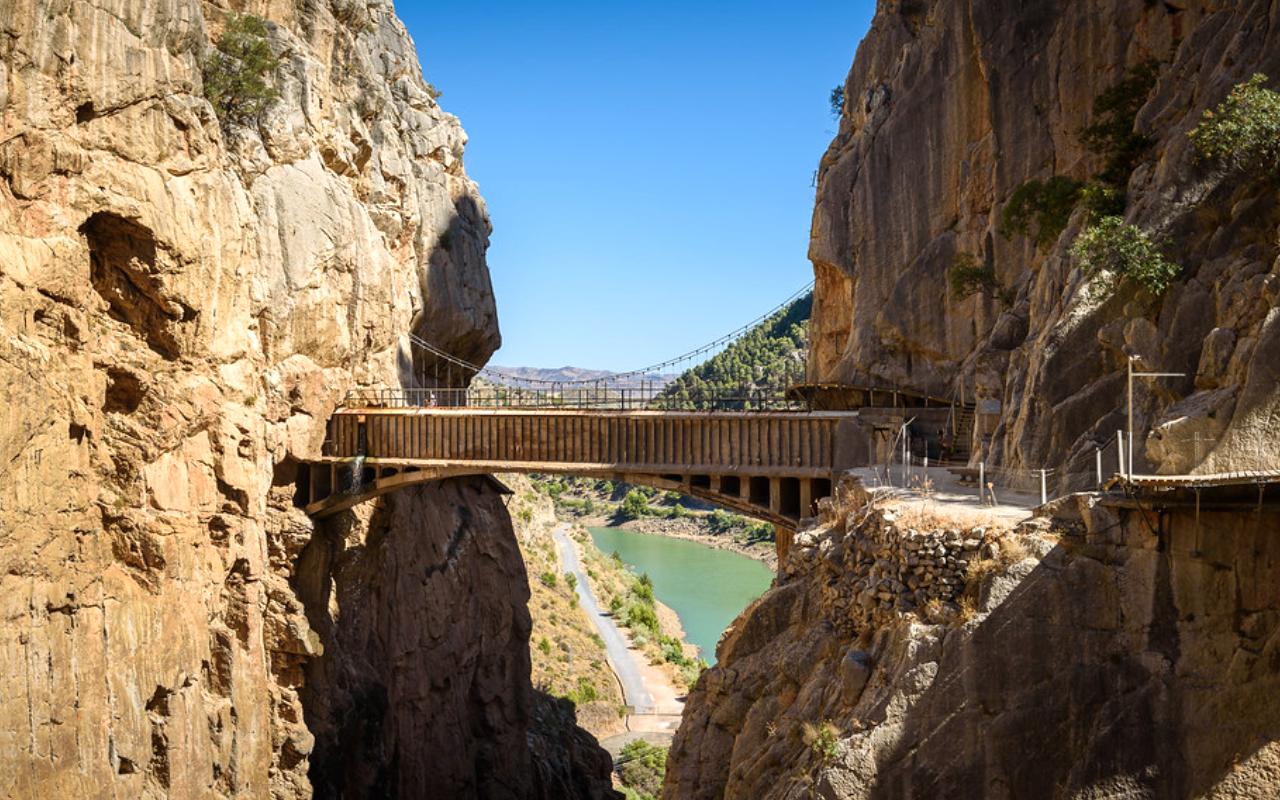
Trail Sections: From the Control Booth, the trail progresses through El Gaitanejo Gorge (2.9 km of cliffside boardwalk), crosses the “Butter Stairs” concrete steps (El Soto pond), then into Tajo de las Palomas and Valle del Hoyo (valley), reaching Puente del Rey (King’s Bridge).
Next comes the Desfiladero de los Gaitanes (main gorge) with suspended boardwalks and a hanging bridge at the deepest section. Finally, the path follows a 2.1 km exit trail (paved) down to El Chorro train station.
Total Distance: Summing approaches and the main path gives 8 km one-way. (Official site lists “Distance: 8 kms”.)
Elevation: Net descent 300 m. The highest start is 600 m above sea level (Ardales), ending 300 m at El Chorro. Gentle ups/downs exist near the exit steps.
Logistics: The trail is linear. A one-way route means hikers must leave a car at El Chorro or arrange a shuttle return. A frequent free shuttle bus (2.5 €) connects the ends (details below).
Trail Map and Highlights of Caminito del Rey
Caminito del Rey
A schematic map (see external tourism sites) shows the starting tunnels near Ardales, long boardwalks on cliffs, and then the exit near El Chorro. Key highlights include:
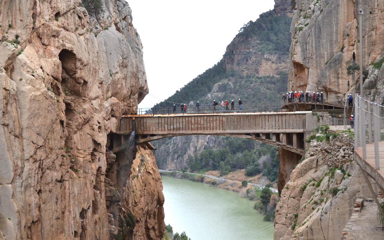
- Gaitanejo Gorge Boardwalk: The longest cliffwalk section (visible in the above photo), with sheer drops.
- El Kiosko Viewpoints: Ruins of an old hotel/resort by Ardales reservoir.
- Butter Stairs: Unique zig-zag concrete steps (for donkeys) at El Soto pond.
- Puente del Rey: A metal footbridge that Alfonso XIII crossed.
- Hanging Bridge: Final suspension bridge across the Gaitanes gorge (famous for photos).
- Tunnel Bypass: A dark tunnel (added in 2017) for weather closures.
(See official site “Access and Route” for detailed section descriptions.)
Tickets and Booking for Caminito del Rey
All visitors must book tickets in advance on the official site (no walk-ins except for a few spare tickets early morning).
Tickets are time-slotted (e.g., “1 p.m.”), and arrival 30 minutes before the slot is required.
| Ticket Type | Price (per person) | Notes |
| General Admission | €10 | Includes entry and helmet; limit 10 tickets per person. |
| Guided Tour | €18 | Official guide (ES/EN) in groups up to 30; includes entry. |
| Shuttle Bus | €2.50 | Optional one-way shuttle (back or forth); must book online or pay on bus. |
| Parking (Ardales) | €2 per day | Park at Visitors’ Centre (Puerto de las Atalayas); reserve online or onsite. |
Standard tickets are strictly €10. Guided tours cost €18 and are highly recommended for English speakers or interest in history.
Children under 8 are not allowed; ages 8–17 must be with an adult and show ID. Visitors must present the original ID (passport or family book) at entry.
Tickets “sell out quickly” during peak season. Sales open in advance: e.g., 2026 tickets for June–December went on sale in April.
There’s a strict cancellation policy: refunds are allowed only for official closure reasons, and tickets are non-refundable. If a selected date is sold out, alternatives include guided tour packages on Viator/GetYourGuide (slightly higher cost).
Booking Tips: Use the official platform to secure the exact date/time you want. On peak weekends or holidays (Easter, summer), book months ahead.
Verify the cancellation policy on the site. Consider booking the optional shuttle bus + parking at the same time for convenience (reserve €2 parking and €2.50 shuttle as add-ons).
Transport Options for Caminito del Rey
By Car: The drive from Málaga takes 1 hour. From Málaga city, take A-357 to Campillos, then exit toward Ardales (MA-5403). This 59 km drive through scenic hills passes towns like Cártama and Pizarra.
Alternatively, approach from Antequera or Ronda (57–60 km routes) via similar roads. GPS “Puerto de las Atalayas” as address (Ctra. de El Chorro, km 57). You can park at the Visitors’ Centre (2 €/day) and hop on the shuttle. Note road signs are in Spanish (look for “Centro de Recepción El Chorro”).
Parking: Two main parking options:
- Ardales (North end): Visitors’ Centre parking near A-357 (pre-book or pay €2 on site).
- El Chorro (South end): Free street parking around the station, but often busy. Use this if driving to the south exit first.
Shuttle: A private bus runs the 5‑10 min route between the north and south ends. Tickets are €2.50 one-way (buy on the website or cash on the bus). On return, same ticket back. First departure 07:40, last 19:00, every 30 min. Shuttle is not operated by Caminito management, but is recommended for logistics.
By Train: Renfe Cercanías C2 line serves the route Málaga–El Chorro (Caminito del Rey) via Álora. There are about 5 trains/day Malaga→El Chorro and 6 from El Chorro→Málaga on weekdays.
The journey (11 min from Alora to El Chorro) costs only a few euros. Check schedules on Renfe.com (service known as “Proximity services”). From El Chorro station, take the shuttle bus to the north entrance. (Note: train frequency is low, so carefully plan times around your ticket slot. There are 2 in the morning, 2 returning in the afternoon.)
By Bus: Local bus M-340 (Álora–El Chorro) departs several times daily (Mon–Sat). It’s the cheapest (≈€2) and takes 25–30 minutes. Buses leave from Álora town center (“Piscina” stop) to El Chorro station. From El Chorro, take the shuttle to the entrance. The return bus also runs from the station back to Álora.
Guided Tours/Transfers: Many companies offer Málaga→Caminito day trips with transport. These include coach or minivan transfers and skip-the-line entry, often at €80–150 pp.
Reputable operators (e.g., GetYourGuide, Viator) can be searched, though not cited here. For independent travelers, a taxi from Málaga directly to the parking costs €60–€80 one-way. Always confirm train/bus times if using public transit.
Best Time to Visit Caminito del Rey
Caminito del Rey is open year-round, but weather and crowds vary widely.
- Spring (Mar–May): Ideal. Mild temps (15–25°C) and blooming flora. April often has the most pleasant weather. This is high season (lots of visitors), so book early.
- Summer (Jun–Aug): Very hot (often >30°C). Advise very early morning slots (before 10 AM) to avoid heat. Be prepared with sunscreen, a hat, and hydration. The walkway may close in afternoon heat spells. Crowds are heavy.
- Autumn (Sep–Oct): Excellent. Warm (20–28°C) and less crowded than summer. Late October sees comfortable hiking conditions.
- Winter (Nov–Feb): Cool (5–17°C) with frequent rain. The trail is open but can close during storms. Dress in layers; bring a rain jacket (umbrellas are not allowed). Fewer visitors make for a quiet trek.
- Time of Day: Early morning is best to beat both crowds and heat. The park opens at 8:30 (winter 9:00). Midday can be uncomfortably sunny. Sunset views (as in photo at right) are spectacular, but note the site closes by 17:00–19:00 (seasonal).
- Crowds: Peak crowds are late spring through early fall. Weekends and holidays fill up fast. Lower season (Nov–Feb) is quieter but riskier weather. Check the official calendar: some Mondays (July–Nov) are open.
- Recommendations: Spring (Mar–May) or fall (Sep–Nov) are sweet spots. Avoid Spain’s hottest afternoons (schedule trips in the morning). Always check weather forecasts; high winds or rain will close the boardwalk for safety.
Hiking Difficulty, Fitness & Accessibility
The Caminito is moderately easy for fit hikers. There is no technical climbing, but the trail is narrow and high (fans of heights may be uncomfortable). The path is mostly flat and downhill.
There are a few uphill steps (especially at the end). Alison on Foot notes it’s “not overly physically demanding”. The distance and sun can fatigue casual walkers, so expect a moderate 10–15 km round trip, including approaches.
Fitness: A reasonable level of fitness is sufficient. Expect 8 km walking one-way over 3–4 hours. Several tour participants (ages 20–60) do it fine. Bring water and take breaks at shaded spots (Benches at El Valle del Hoyo pond).
Age/Health: No children under 8 by law. Ages 8–17 must have adult supervision and ID. Senior visitors (70+) should consult a doctor if they have mobility or heart issues; parts of the path (stair sections) could be tiring. The path is not wheelchair/stroller accessible.
Accessibility: The trail is rugged: no wheelchairs or pushchairs. The northern approach from Ardales requires walking long, sloped access paths. The boardwalk itself is steel-grate (safe, but uneven underfoot) with metal handrails along cliff edges.
Restrictions: Guide’s advice and official rules must be followed. Pets are prohibited (no exceptions for small dogs). No children on shoulders. Smoking and drones are banned for safety.
In summary, be prepared for a multi-hour cliff hike: wear comfortable hiking shoes (no sandals or heels), carry water, and be ready for heights. The panoramic views reward the effort.
Caminito del Rey Safety Rules, Regulations & Incident History
Caminito del Rey
Visitor safety is paramount. The mandatory rules include:
- Tickets/Check: Must arrive 30 minutes early with printed/digital ticket and ID. Entry is via the north only; returning to Ardales by exiting is forbidden.
- Helmet & Gear: You will be given a helmet at the checkpoint and must wear it at all times. Appropriate footwear is required; no flip-flops, high heels, or open-toe shoes allowed. Staff may check shoes.
- Behavior: No running or horseplay. Keep the group pace. Do not cross barriers or leave the authorized path. Follow the instructions of guides/staff.
- Prohibited Items: Big backpacks, drones, hiking poles, selfie sticks, umbrellas, pets, and smoking are all forbidden.
Violating rules can lead to fines or expulsion. The authorities reserve the right to close the trail for safety (weather, rockfall).
Incident History of Caminito del Rey
After its restoration, Caminito is statistically very safe, but two unrelated climbing accidents made news in 2024–25. In Jan 2025, a 21-year-old woman fell to her death near Caminito (via ferrata route), the second fatal accident in the area that month. (Earlier, a 20-year-old man died on the via ferrata in Dec 2024.)
These incidents were on adjacent climbing routes, not the designated boardwalk. The official Caminito walkways are engineered with railings, and helmets are provided, so fatal falls on the path itself have not occurred since reopening. Nevertheless:
- Key safety takeaways: Always stay behind the protective mesh and railings, do not attempt shortcuts, or get too close to cliff edges. The boardwalk has periodic safety checks by staff.
- Regulation enforcement: Local police and park rangers monitor compliance. In the old days (1999–2000), five visitors died on the crumbling original path, so those sections were closed and rebuilt.
In summary, adherence to rules (helmets on, no climbing fences) makes the hike very safe. Check the weather; high winds can close exposed areas (the tunnel bypass is used if needed).
With precautions, enjoy the thrill of walking safely in one of Europe’s most dramatic settings.
What to Wear and Pack
Footwear & Clothing: Wear sturdy closed shoes with good tread (hiking boots or sneakers). The path is mostly flat, but uneven and narrow in places. No flip-flops or open shoes.
Dress in lightweight layers: even in summer, the gorge can be cool in shade. In winter, a waterproof jacket is wise. Official rules ban any unsuitable shoes.
Essentials to Pack:
- Water: At least 1–2 L per person (no fountains on route).
- Snacks: Energy bars or fruit; a picnic at El Chorro station is popular.
- Hat/Sunglasses/Sunscreen: Strong sun; the bridge and boardwalk have no shade.
- Camera/Phone: For amazing photos (no selfie sticks).
- Light Gloves: (optional) for gripping rails if hands get sweaty.
- Small Daypack: Under seatback size (big bags may be restricted).
- Identification: Passport/ID for all adults and children.
- Extra Layer: A light hoodie or rain poncho, especially in shoulder seasons.
- Cash: A few euros (for parking/shuttle if paying on-site; vending machine at entrance).
What Not to Bring: As noted, bulky backpacks, tripods, drones, or umbrellas. Umbrellas and hiking poles are disallowed (can damage the mesh or block others). Pets and smoking are strictly banned. Carry only what you need for the day. Note: A small kit (sunscreen, basic first-aid) is good practice for any hike.
Photography Tips
The Caminito offers postcard-perfect views. To capture them:
- Bring a wide-angle lens (or use panorama mode on a phone) to include the gorge scale.
- Timing: Sunrise and late afternoon light create dramatic shadows on the cliffs. However, these times can coincide with restricted hours (the walk starts at 8:30 and ends by sunset).
- Notable photo spots: The suspended King’s Bridge, the final hanging bridge across Gaitanes, and long shots of the boardwalk clinging to rock. Also, the mirrored reservoir at El Chorro.
- Exposure: Some sections (like the first boardwalk) have deep shadows under the cliffs; HDR or fill-flash can help.
- Equipment: A small tripod may be OK on flat sections, but many discourage bulky gear due to the crowd. Smartphone or mirrorless cameras work well. Avoid DJI drones (banned).
- Safety: Keep one hand on the rail when focusing, and never lean outward.
- Photography is part of the experience, so take time at wider ledges like El Valle del Hoyo pond. These panoramic vistas and the walkway itself are what visitors rave about.
Nearby Attractions & Itineraries
Ardales
Caminito is often part of a multi-activity trip. The region offers historical sites, nature parks, and villages to fill one or two days.
- Ardales: Charming village (4 km from the north entrance). Visit the Cueva de Ardales Paleolithic cave (prehistoric art) and the Necropolis of Las Aguilillas.
- El Chorro: Small settlement by reservoirs. Check out the hydroelectric dams and the submerged fishing village (visible in drought). Rock climbers will recognize the crags. The El Chorro train station (exit point) has a café.
- Antequera: 30 km north, famous for prehistoric Dolmens (UNESCO site) and Alcazaba fortress.
- El Torcal Natural Park: South of Antequera, known for strange limestone “karst” towers.
- Ronda: Historic mountain town (80 km west) with famous Puente Nuevo and bullring.
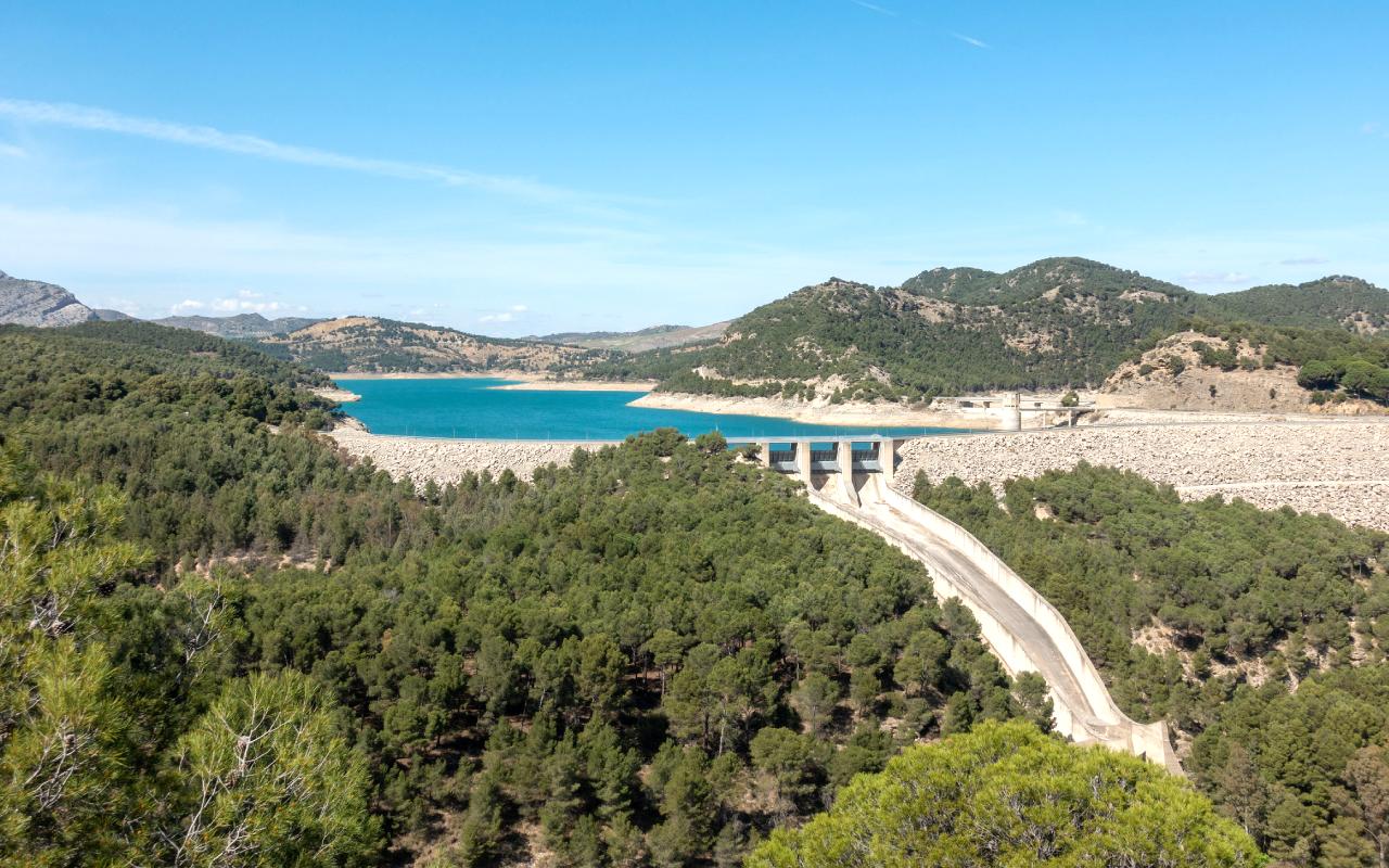
- Lakes & Parks: Guadalteba and Guadalhorce reservoirs around Caminito; the Great Trail of Málaga (GR 249) links local paths for hiking/biking.
Sample 1-Day Itinerary of Caminito del Rey
For a one-day visit from Málaga, plan early:
| Time | Activity |
| 07:00 | Depart Málaga (car/train to Ardales) |
| 08:00 | Arrive Ardales Reception Centre; park & board shuttle |
| 08:30 | Arrive at Caminito North Entrance; check tickets, helmets |
| 08:45 | Begin Caminito hike (north→south) |
| 11:30 | Finish hike at El Chorro station; enjoy lunch |
| 13:00 | Shuttle/train back to Ardales or Málaga |
| 14:00 | (Optional) Visit Ardales cave or the local museum |
| 17:00 | Return to Málaga |
This table assumes an 08:45 entry time. Adjust if using guided tours or buses. Allow 30–45 min for exit logistics (helmet return, etc). The afternoon could include Ardales’ attractions or just relaxing by the reservoirs.
Sample 2-Day Itinerary of Caminito del Rey
Day 1: Málaga → Caminito hike → stay locally.
Day 2: Explore nearby highlights:
- Morning in Antequera (dolmens, fortress).
- Afternoon at El Torcal (short hikes).
- Return to Málaga by evening.
Alternatively, combine Caminito with Ronda or coastal stops (Nerja) if extending.
Accommodation and Dining
Where to Stay:
- Ardales and El Chorro have rural hotels and B&Bs (e.g., Cortijo del Arte, El Cielo Azul) around €50–€120/night.
- Málaga city (40–60 min drive) offers many hotels (€80+ night) and is best if combined with a wider Andalusia trip.
- Antequera and Ronda (1h drive) have lodging and make good bases for multi-day trips.
Dining:
Nearby villages have a few cafés and taverns. For example, Restaurante El Kiosko at the north start (snacks, paella) and small eateries in Ardales and El Chorro. Typical Andalusian fare, gazpacho, grilled fish, and tapas.
Expect €10–20 for a main dish. The Caminito route itself has no services, so pack water and snacks. In Málaga (returning) you’ll find all price ranges in the city (from casual tapas bars to fine dining).
For fresh local products, try cheeses and wine in nearby villages. In summer, finishing with a cold drink at the Chorro kiosks is popular. Always have cash; small villages may not take cards.
FAQs and Common Mistakes
What if I’m late for my slot?
You must arrive ≤15 min after your booked time or risk denial of entry. No refunds if late.
Can I cancel or change the date?
Official tickets are non-refundable and non-transferable unless the trail is closed by authorities. Book carefully.
Is there a restroom on the route?
Restrooms are only at the start (north entrance). No facilities mid-trail. Plan ahead at the station or kiosks.
Can I bring my dog?
No pets allowed anywhere on the path.
Do I need travel insurance?
Tickets include basic liability insurance, but consider personal travel insurance for emergencies.
How can I ensure safety if I’m concerned about language or injuries?
If worried about language or injuries, consider booking an official guided tour (with a guaranteed group and guide).
What are some common mistakes?
Underestimating the hike, people forget the one-way logistics and end up having to hitchhike or buy expensive taxi rides. Always plan exit transport (return shuttle or train) in advance.
Are there any other tips to follow?
Bring a light snack/energy bar for after the hike; the El Chorro station area has limited food choices.
Conclusion
Caminito del Rey is an amazing and exclusive hiking adventure that integrates history, scenic views, and contemporary safety measures. Since its inception as a narrow footpath, its regeneration as one of the most visited tourist spots in Spain.
This cliffside trail gives its visitors the opportunity to stroll through the breathtaking Gaitanes Gorge and admire the panoramic view of the rugged landscape in Andalusia.
It is a journey to remember, whether you are an adventure traveler, a photography lover, or just want to see one of the most dramatic natural landscapes in Europe.
To have a safe and enjoyable visit, you should observe all safety measures, purchase your tickets beforehand, and organize the season. Its rich history and stunning views make Caminito del Rey a memorable experience for anyone who is willing to get the adrenaline rush of walking through one of the most recognized paths in Spain.


-
 0115 Best Easy Treks in Nepal for Beginners and Families
 -
 02Best season for Everest Base Camp Trek
 -
 03Best Time to Go Hiking in Nepal: A Seasonal Guide for Trekkers
 -
 04Suchi Purja –Wife of Nirmal Purja aka Nims Dai
 -
 05Top Beaches in Sri Lanka
 -
 06Dubai desert safari outfit ideas
 -
 0710 Best Easy Treks in Nepal